Data & GIS Services
Double-blind keying, quality control, and county GIS maps embedded in your title plant.
Our Tucson-based data team specializes in title plant indexing, geographic mapping, and quality control for title agencies, settlement companies, and shared plant operators. Using double-blind keying methodology and rigorous validation protocols, we maintain title plant accuracy rates below 0.25% across millions of indexed instruments.
Whether you need ongoing county posting, historical back-plant keying, digital ARB creation, or GIS integration, DSI provides the data quality and mapping expertise title professionals require - without the overhead of building these capabilities in-house.
indexing error rate across DSI-maintained title plants
Related Products
Quality Data Keying Services
Double-Blind Keying Methodology
Every instrument entered into a DSI-maintained title plant passes through two independent keyers. Our quality control system compares both entries field-by-field, flagging any discrepancies for supervisor review before data is committed to the plant.
- First keyer indexes grantor, grantee, legal description, instrument type, and recording details
- Second keyer independently keys the same document without seeing the first entry
- Automated comparison identifies mismatches in any field
- Supervisor review resolves discrepancies and validates the final entry
- Quality audit samples completed work for additional verification
The result: error rates consistently below 0.25%, eliminating costly title defects caused by indexing mistakes.

Geographic Title Plant Indexing
Our data team has deep expertise in geographic indexing systems - tracking property ownership by land location rather than name-based indices. Geographic plants require specialized knowledge of sectional descriptions, subdivision mapping, and parcel identification.
- Section, township, and range posting
- Subdivision lot and block indexing
- Metes-and-bounds legal description parsing
- Parcel identifier cross-referencing
- Tax assessor account number linking
We maintain geographic title plants across multiple states, with particular expertise in indexing standards for Arizona, California, Nevada, and Texas.
Go-Forward County Posting
DSI monitors county recorder offices daily, downloads new recordings, and posts instruments to your title plant on a fast turnaround. Our team handles all document types, including deeds, mortgages, releases, liens, easements, and specialty instruments.
DSI configures keying protocols to match your examination standards - which instruments to post, which to skip, and how to handle partial releases, bankruptcy notices, and other exceptional cases.
Back-Plant Keying Projects
Need to digitize historical county records or convert paper plant cards into a modern system? DSI manages large-scale back-plant projects from document sourcing through final quality validation.
- Historical depth analysis spanning multiple decades of records
- Document acquisition from county recorders or microfilm archives
- High-volume keying with accelerated timelines
- Image scanning and OCR processing, where applicable
- Final plant validation and examiner acceptance testing
Timelines vary by county size; large-scale projects of roughly 100,000 instruments typically complete in six to twelve months with dedicated keying teams.

Digital Drawing & GIS Maps
DSI embeds county GIS maps directly into your title plant. Our drawing specialists convert legal descriptions into digital shapes that become permanent layers in Alphamax - making sectional examination faster and more accurate.
Digital ARB Creation
"ARB" stands for arbitrary number - the unique parcel identifier assigned in geographic title plants. Our drawing specialists convert complex legal descriptions into digital parcel shapes (digital ARBs) that overlay county GIS maps.
- Legal description interpretation: parse metes-and-bounds, lot-and-block, or sectional descriptions
- Coordinate plotting: convert bearings, distances, and curves into geographic coordinates
- Shape creation: generate parcel polygons in GIS-compatible formats
- Quality validation: verify closures, check for overlaps, compare to county cadastral data
- Plant integration: load digital shapes into Alphamax 3 or other title plant systems
Digital ARBs give examiners instant visual confirmation of parcel boundaries, flag adjoining parcels and potential conflicts immediately, calculate acreage automatically, and let you layer additional data - tax, zoning, flood zones - over the property outline.
County GIS Integration
DSI integrates official county GIS base layers directly into title plant systems, replacing outdated paper sectional maps with current, interactive geographic data.
DSI integrates GIS data into Alphamax 3 and can provide map exports for other title plant systems.
Subdivision Mapping
When new subdivisions are recorded, DSI creates digital plat maps showing individual lots, blocks, tracts, and common areas. These maps integrate directly into your title plant for visual lot identification during examination.
- Plat digitization from recorded documents
- Lot and block numbering
- Easement and common area delineation
- Phase tracking for multi-phase developments
- Amendment and replat updates
Plotted Easements
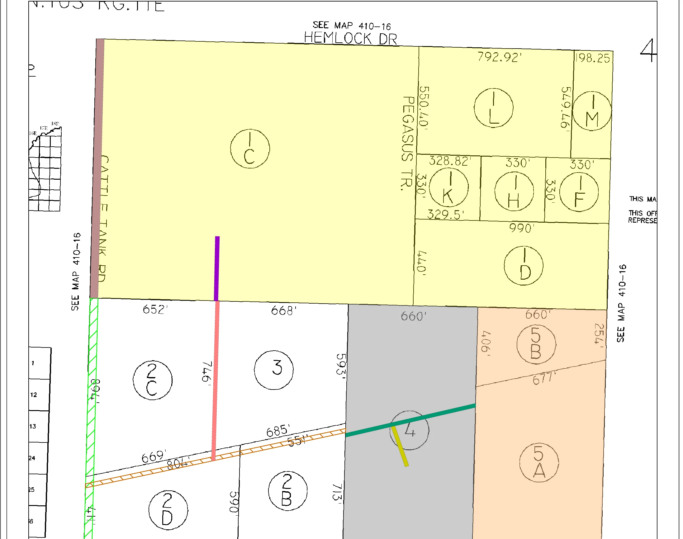
Easements identified during subdivision mapping and go-forward posting are plotted directly from their legal descriptions onto the parcel map, giving examiners a precise, visual record of every right-of-way, utility, and access easement affecting a property - not just the recorded text.
Offshore Keying Partnership Management
Quality Control API
DSI's application programming interface sits between offshore keyers and your title plant, validating every entry against configurable business rules.
For title agencies with existing offshore keying vendors, DSI provides quality-control middleware to ensure data meets your standards before committing to the plant.
Quality Gates
Only correctly formatted instruments that pass all validation rules commit to the plant. Exceptions route to DSI's Tucson team for review and correction.
Your Control
Define acceptance thresholds, rejection criteria, and escalation rules. DSI provides monthly quality scorecards showing offshore vendor performance.
Data Quality Reporting
DSI provides transparent quality metrics for all keying and mapping services.
- Total instruments posted, by document type
- Error rate calculations (target: below 0.25%)
- Turnaround time from recording to plant availability
- Exception handling statistics
- Offshore vendor performance, where applicable
Request random sample audits anytime to verify ongoing accuracy standards.
Who Uses DSI Data Services?
Shared Title Plant Operators
Maintain multi-subscriber plants with consistent quality standards across all participants.
Independent Title Agencies
Outsource daily posting to focus internal staff on examination and customer service.
Title Plant Conversion Projects
Digitize paper plants or migrate from legacy systems with expert keying and quality assurance.
Multi-State Operations
Centralize data quality management across plants in different states and counties.
Agencies with Offshore Vendors
Add a quality control layer between offshore keyers and production systems.
Technology & Security
Data Center
SOC 2 Type II compliant hosting for all title plant data.
Access Controls
Role-based permissions, audit logging, and encrypted transmission.
Backup & Recovery
Daily automated backups with geographic replication - local and cloud-based - so title files, escrow records, and client data stay protected and recoverable.
Staff Security
Background checks, confidentiality agreements, and secure facilities for every team member handling your data.
Service Levels & Pricing
Data and GIS services pricing varies based on volume, complexity (document types, custom posting rules, geographic indexing), turnaround requirements, and integration needs.
Your Data. Keyed Right the First Time.
Our Tucson-based data team has populated and maintained title plants for counties across the Southwest. Double-blind keying means two operators independently enter every record - discrepancies are flagged and resolved before data ever reaches your plant. Built in Tucson since 1985.
Contact Us